
Repeat after me: Map apps can be useful, but you should not follow their advice blindly. For example, if you’re on your bike and it tells you to cycle through a tunnel meant only for cars. Don’t do that. [More]
maps
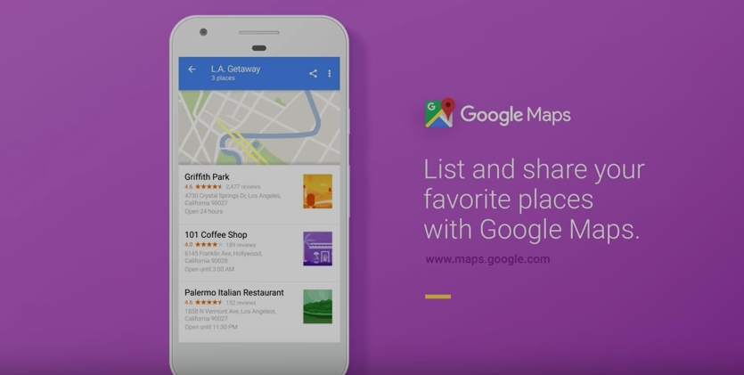
Is Google Trying To Make Maps A Social Network?
By 2.13.17
Sure, it might seem social networking giants like Snapchat and Instagram continuously mimic each other in a phenomenon we’re calling “samification,” but now it looks as if a seemingly unrelated app is dipping its toes in the social pool, too: Google is adding a more social, sharable function to its Maps app. [More]
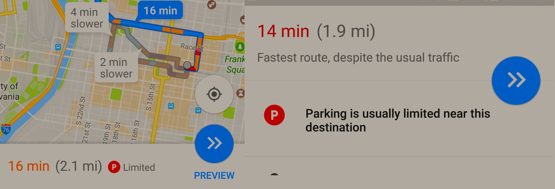
Google Maps Parking Assistant Is Live In 25 Cities
By 1.26.17 — Updated: 1.27.17
That didn’t take long. Just a week after a beta test of Google Maps’ latest app version showed the company was testing a new feature intended to alert users to potential parking problems, the service is now live. [More]
Apple Reportedly Taking On Google Maps With Road-Tracking Drones
By 12.1.16
When it comes to tracking and recording America’s roadways it makes sense that companies like Google would deploy camera-equipped vehicles to cruise the streets. But Apple has a different idea: take to the sky. [More]

Snapchat Uses Vending Machines to Sell ‘Spectacle’ Smart Sunglasses
By 11.10.16
Forget about pop-up stores or branded kiosks. The new thing for selling your tech product is apparently vending machines — at least according to SnapChat, which is using bright yellow dispensers to market its new line of Spectacle photo- and video-taking sunglasses. [More]
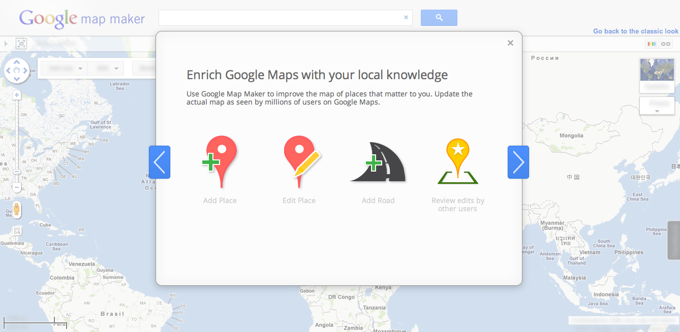
Google Shutting Down Crowdsourced “Map Maker” Editing Tool
By 11.9.16
After eight years or so of offering people the chance to edit Google Maps through a tool called Map Maker, the company says it’s going in a different direction, and will be retiring the standalone project in March 2017. [More]
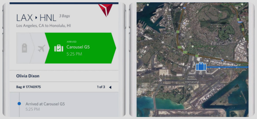
Delta App Update Allows Travelers To Track Their Checked Bags On A Map
By 10.26.16 — Updated: 10.31.16
Over the past year, several airlines have experimented with different programs that allow passengers to track their checked luggage: from electronic baggage tags at Alaska Airlines to real-time tracking at American Airlines. Now, Delta Air Lines is jumping on the bandwagon, updating its app with a map that shows the real-time location of bags. [More]
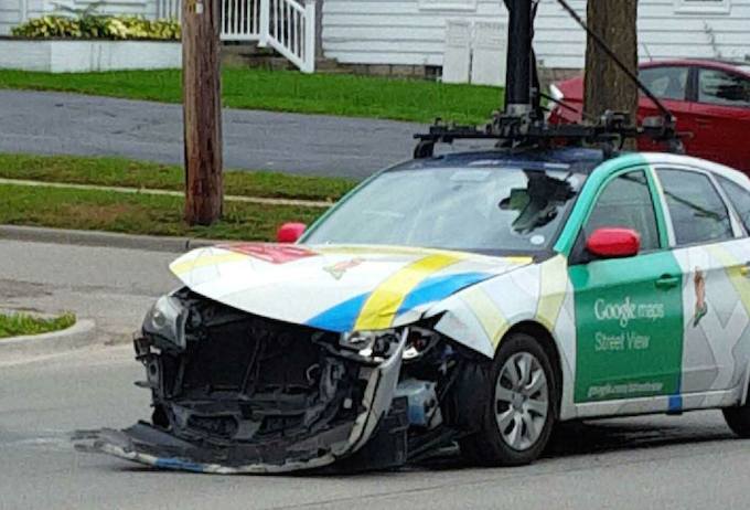
Google Street View Car Involved In “Minor” Accident With Another Vehicle
By 10.5.16
Google Street View cars see a lot of stuff when they’re out cruising the highways and byways of the world, including traffic collisions. Whether or not one mapping car in Michigan captured its own accident on camera, we can only guess, but at least one bystander was on hand to snap a photo of the event. [More]
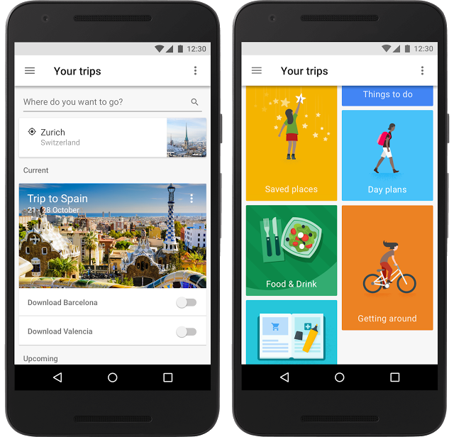
Google Debuts Personalized Travel Planner Dubbed “Google Trips”
By 9.19.16
As anyone who’s ever found themselves standing around a police station in Spain at 3 a.m. calling mom back in the U.S. for their own hotel info can attest, it can be really tough when you’re lost in a foreign country or city without an Internet-connected device. Google wants to make those kinds of experiences easier and help travelers coordinate their activities with a new travel planning app called “Google Trips.” [More]
This Farm In Kansas Is The Default Address For All American Internet Users
By 4.11.16
The geographic center of the United States, as all elementary school students know, is in Kansas. When some services that map a device’s Internet Protocol address don’t know where someone using a website is located, they point to the front yard of a farm in Kansas. The octogenarian owner and her tenants had no idea until recently why they were being harassed. [More]
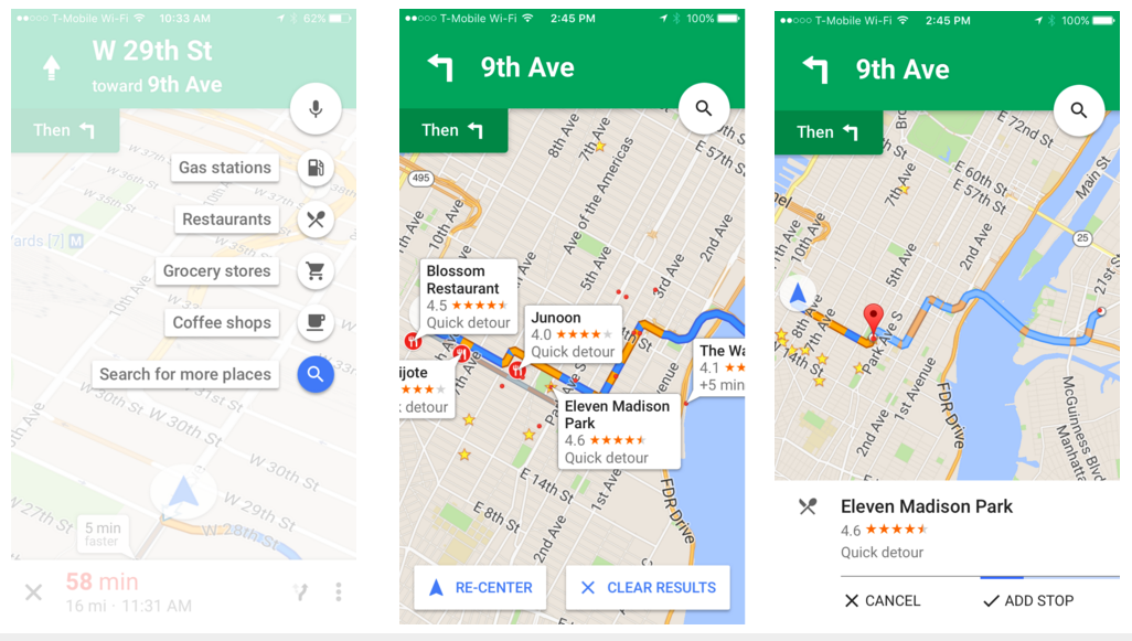
You Can Now Add Pit Stops In Google Maps On iOS Devices
By 3.1.16
Anyone who’s ever been on a road trip know that pit stops are essential: you may need a bathroom break, or emergency beef jerky and a tuna sandwich in a triangular plastic wedge. For anyone who’s ever found themselves getting lost while trying to find a gas station or restaurant on the road, you’ll likely be glad to hear that you can now add those pit stops to your route in Google Maps on iOS devices. [More]
Google Maps Launches Offline Navigation And Search Options
By 11.10.15
As it was foretold back in May, so it has come to pass: for all those times when you need to know where you’re going but don’t have great Internet service, Google Maps has introduced offline navigation and search. [More]

Google Testing Feature That Lets You Put Your Food Photos On The Map
By 8.24.15
If you’re a diner that enjoys providing your social media followers with (sometimes) artistic shots of the food you plan to shove down your throat, but are getting tired of just getting little hearts from Instagram, have no fear. Google is reportedly working on a new feature that will put your foodie photos on the map, literally. [More]
Google Maps Restoring Map Maker Editing Feature
By 8.13.15
After an image of an Android bot urinating on an Apple logo popped up in Google Maps and prompted the company to temporarily shut down Map Maker, which allows users to edit maps, the company says the feature will be reopening in phases. [More]

Google Maps For iOS Adds Night Mode To Make It Easier To Navigate After Dark
By 8.7.15
There’s nothing quite like the white glare of your phone’s map app to annoy a driver at nighttime. Which is why Google Maps for iOS will now include a “night mode” with a darker background, making it easier for drivers to navigate in the dark. [More]
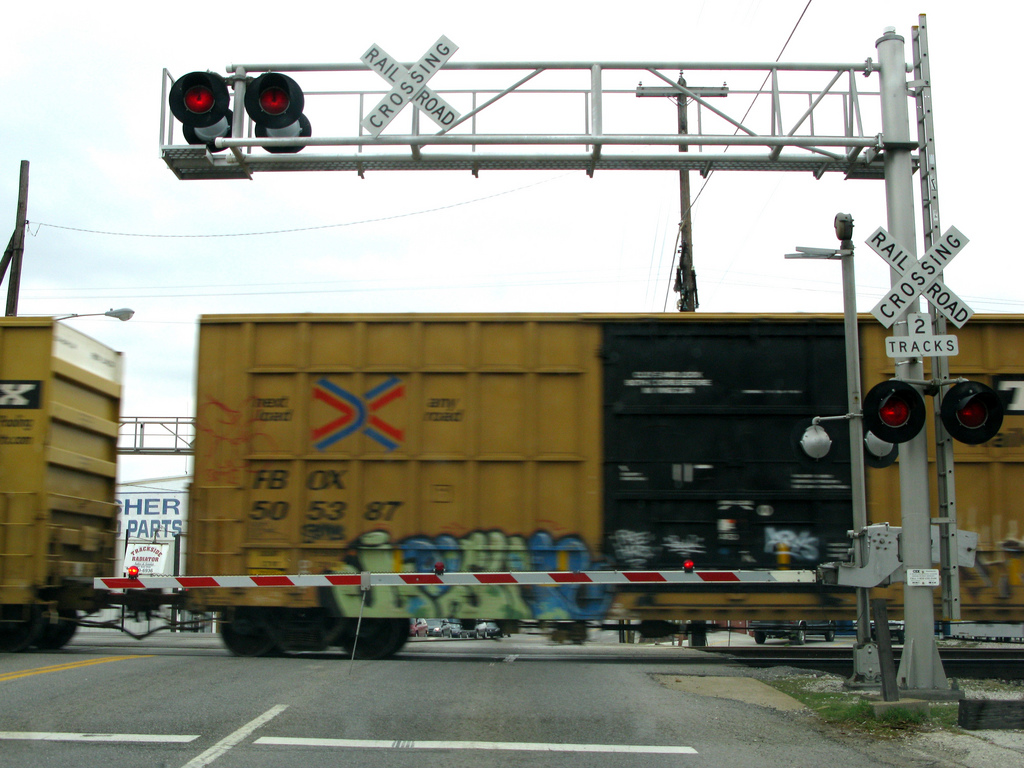
Google Adding Railroad Crossings To Maps In Attempt To Curb Accidents
By 6.29.15
Due to an uptick recently in accidents at railroad crossings, the Federal Railroad Administration is stepping up efforts to keep drivers aware when their route intersects with the path of trains. The agency just announced a new partnership with Google Maps, that will provide the locations of all grade crossings in the country. [More]
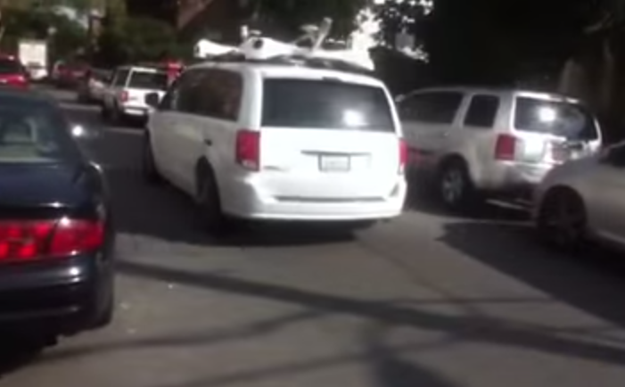
Apple Confirms It’s Sending Out Camera-Equipped Cars In An Effort To Improve Its Maps
By 6.10.15
As Apple continues on its daunting task of improving Apple Maps’ reputation, the company is looking to the streets. Specifically, it’s trying out that whole Street View thing Google has been doing, sending out vehicles equipped with cameras to snap photos of the world’s highways and byways. [More]
Google Maps Adding Offline Search And Navigation “Later This Year”
By 5.28.15
For all those times you’ve glanced around at an unfamiliar intersection, cursing the wireless signal gods for denying your phone service and thus depriving you access to mapping apps, Google says it’s here to help: The company announced today that soon Google Maps will offer offline search and navigation capabilities. [More]